Happy travels Scott. Enjoy. Try to sleep tonight. I generally don't sleep well the night before a moto trip due to the excitement and anticipation.
-
Required reading for all forum users!!!
Welcome!
Register to access the full functionality of the GSResources forum. Until you register and activate your account you will not have full forum access, nor will you be able to post or reply to messages.A note to new registrants...
All new forum registrations must be activated via email before you have full access to the forum.A Special Note about Email accounts!
DO NOT SIGN UP USING hotmail, outlook, gmx, sbcglobal, att, bellsouth or email.com. They delete our forum signup emails.A note to old forum members...
I receive numerous requests from people who can no longer log in because their accounts were deleted. As mentioned in the forum FAQ, user accounts are deleted if you haven't logged in for the past 6 months. If you can't log in, then create a new forum account. If you don't get an error message, then check your email account for an activation message. If you get a message stating that the email address is already in use, then your account still exists so follow the instructions in the forum FAQ for resetting your password.Have you forgotten your password or have a new email address? Then read the forum FAQ for details on how to reset it.
Any email requests for "can't log in anymore" problems or "lost my password" problems will be deleted. Read the forum FAQ and follow the instructions there - that's what we have one for...
-
Returning Visitors
If you are a returning visitor who never received your confirmation email, then odds are your email provider is blockinig emails from our server. The only thing that can be done to get around this is you will have to try creating another forum account using an email address from another domain.
If you are a returning visitor to the forum and can't log in using your old forum name and password but used to be able to then chances are your account is deleted. Purges of the databases are done regularly. You will have to create a new forum account and you should be all set.
You are using an out of date browser. It may not display this or other websites correctly.
You should upgrade or use an alternative browser.
You should upgrade or use an alternative browser.
My Blue Ridge Parkway Ride 2016
- Thread starter cowboyup3371
- Start date
Thanks Glen. I am the same way and, for me, the anticipation usually starts a day or two before.

Pretty sure it's 20 over before it becomes a felony there, but maybe that was a bit of fun there. Safe-and fun-travels, Scott!
Pretty sure it's 20 over before it becomes a felony there, but maybe that was a bit of fun there. Safe-and fun-travels, Scott!
Yes, you are right. In Virginia it is speeding up to 19mph over the speed limit. It is reckless operation anything over that. Reckless Operation is the same level of offence as a DUI. Just keep it cool in Virginia, Virginia.

Steve
GS Whisperer
Also keep in mind that part of the Blue Ridge Parkway is in Virginia, but it's a National Park, so Virginia laws may not apply. :-k
It may be worse.

It will also help to keep in mind that the speed limit on most of the Parkway is 45 mph. In some congested areas it's 35.
The road is a SCENIC RIDE, not a race track, so ride it accordingly.
.
It may be worse.
It will also help to keep in mind that the speed limit on most of the Parkway is 45 mph. In some congested areas it's 35.
The road is a SCENIC RIDE, not a race track, so ride it accordingly.
.
Also keep in mind that part of the Blue Ridge Parkway is in Virginia, but it's a National Park, so Virginia laws may not apply. :-k
It may be worse.
It will also help to keep in mind that the speed limit on most of the Parkway is 45 mph. In some congested areas it's 35.
The road is a SCENIC RIDE, not a race track, so ride it accordingly.
.
I'm there to see the scenery on this ride since too many things are closed and not to be a part of the next MotoGP3 crowd so yes, i'm planning on taking it easy. I also heard from a guy I work with that the road can get real slippery from any leaves that will be on the ground so I'm going to take it smart.
Most of the BRP from Asheville to the Virginia line has been repaved. Rode it in June and it was sweet.
Made it to Elkins with everything in one piece; well almost everything. One of Stator’s boots broke so I’ll need to make some repairs on him when we get home. Did have one pucker factor moment today though when the back tire grabbed what I think was some gravel in the road I didn’t see. It only lasted about two seconds but that was definitely hair raising. Otherwise it was a fairly uneventful and fun ride.
I also ran the new GoPro all day thanks to a battery pack and the time warp feature so I should have some good videos when I get back. That is a nice change from my previous trips.
When I took my first water break at a roadside park, Stator and I noticed this playground wasn't like all of the ones you usually see anymore. No, it actually had real old fashioned METAL toys like we had growing up. So, of course he had to go check it out.
 First Water Stop by Scott Baker, on Flickr
A short climb up the slide
 Stator Climbing Slide by Scott Baker, on Flickr
and the little hop over the edge followed by the loop-the-loop was fun he said; of course it was hot so he wasn't about to lay there too long
 Stator at bottom of slide by Scott Baker, on Flickr
Then it was off to the merry-go-round and swing
 Stator on Merry Go Round by Scott Baker, on Flickr
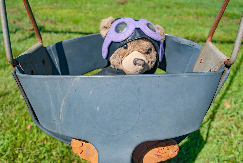 Stator in Swing by Scott Baker, on Flickr
Although we needed to leave, he insisted on practicing his climbing skills, afterall he is a bear
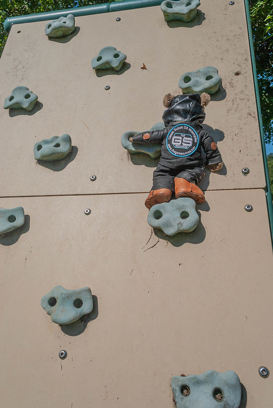 Stator Climbing Rock Wall by Scott Baker, on Flickr
After lunch at a fantastic mom and pop shake shop interesting named the Shake Shoppe in Gallipolis, we started our ride into West Virginia arriving into Elkins late in the afternoon. I had the road mostly to myself which was nice.
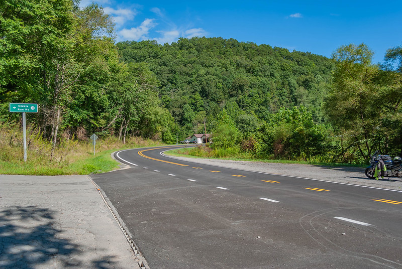 US33 Water Stop by Scott Baker, on Flickr
I would love to go back and visit this place, maybe even stay awhile. It's a Lunatic Asylum built during the Civil War and has a pretty interesting story based on the story boards. They provide tours but i got there too late that day.
 Trans-Allegheny Lunatic Asylum by Scott Baker, on Flickr
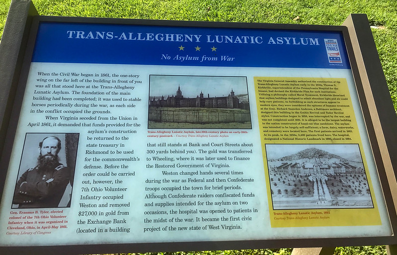 Trans-Allegheny Lunatic Asylum Sign by Scott Baker, on Flickr
Sadly, the sunset never hinted what was going to happen the next morning.
 Sunset in Elkins WV by Scott Baker, on Flickr
Tomorrow is Front Royal VA and the Manassas battlefield
I also ran the new GoPro all day thanks to a battery pack and the time warp feature so I should have some good videos when I get back. That is a nice change from my previous trips.
When I took my first water break at a roadside park, Stator and I noticed this playground wasn't like all of the ones you usually see anymore. No, it actually had real old fashioned METAL toys like we had growing up. So, of course he had to go check it out.
First Water Stop by Scott Baker, on FlickrA short climb up the slide
Stator Climbing Slide by Scott Baker, on Flickrand the little hop over the edge followed by the loop-the-loop was fun he said; of course it was hot so he wasn't about to lay there too long
Stator at bottom of slide by Scott Baker, on FlickrThen it was off to the merry-go-round and swing
Stator on Merry Go Round by Scott Baker, on FlickrStator in Swing by Scott Baker, on FlickrAlthough we needed to leave, he insisted on practicing his climbing skills, afterall he is a bear
Stator Climbing Rock Wall by Scott Baker, on FlickrAfter lunch at a fantastic mom and pop shake shop interesting named the Shake Shoppe in Gallipolis, we started our ride into West Virginia arriving into Elkins late in the afternoon. I had the road mostly to myself which was nice.
US33 Water Stop by Scott Baker, on FlickrI would love to go back and visit this place, maybe even stay awhile. It's a Lunatic Asylum built during the Civil War and has a pretty interesting story based on the story boards. They provide tours but i got there too late that day.
Trans-Allegheny Lunatic Asylum by Scott Baker, on FlickrTrans-Allegheny Lunatic Asylum Sign by Scott Baker, on FlickrSadly, the sunset never hinted what was going to happen the next morning.
Sunset in Elkins WV by Scott Baker, on FlickrTomorrow is Front Royal VA and the Manassas battlefield
Last edited:
Wow! What a day. I can finally put another state on my list of places I have been. I made it to Front Royal after the longest four hour ride I think I have ever had. Before I left Dayton the weather forecasts for this week said 20% chance of spotty thunderstorms. I swear the person who wrote that should be fired as it started raining cats and dogs before I woke up and didn’t look like it would stop at all.
The radar looked like I might get a break around 1pm but with a noon checkout I thought I would wait and grab lunch before leaving Elkins. However, about 1030 I looked outside and noticed it had quit so I quickly loaded up and grabbed some gas.
 Storm Clouds East of Elkins by Scott Baker, on Flickr
I made it to my first stop at Seneca Rocks where I managed to get some pictures. However, after about 20 minutes the skies opened up again and so off I went.
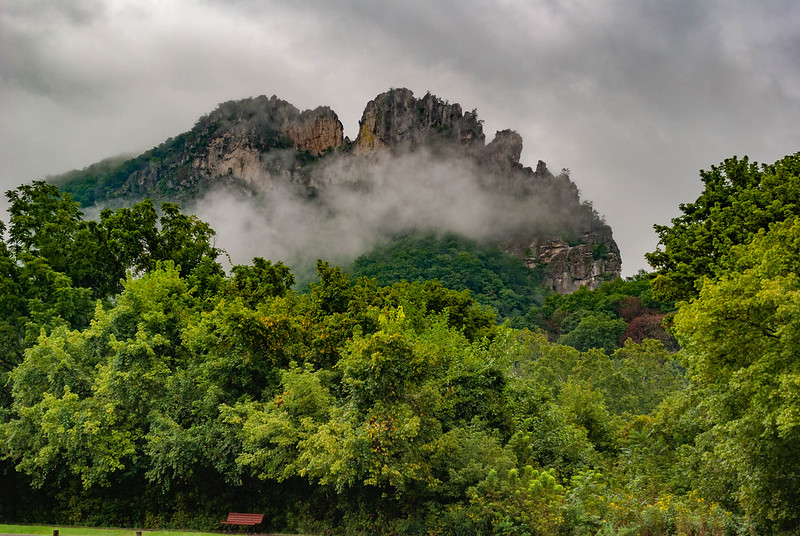 Seneca Rocks Covered by Clouds by Scott Baker, on Flickr
 Seneca Rocks No Clouds by Scott Baker, on Flickr
US-33 is a nice road and looks to be a blast when it’s dry but 3 to 10-percent grades are not fun when it’s wet. I kept the bike to at least the recommended curve speeds the entire way down and really under the speed limit for the rest of the ride. In fact, I’m sure the dump truck driver behind me at one point probably cursed me out a few times despite keeping back far enough to not crowd me.
The weather looked ugly enough and my gear was so soaked that I’ll need to bypass Manassas on this trip. I’m hitting Skyline and BRP tomorrow with a stop in Appomattox for the night.
The radar looked like I might get a break around 1pm but with a noon checkout I thought I would wait and grab lunch before leaving Elkins. However, about 1030 I looked outside and noticed it had quit so I quickly loaded up and grabbed some gas.
Storm Clouds East of Elkins by Scott Baker, on FlickrI made it to my first stop at Seneca Rocks where I managed to get some pictures. However, after about 20 minutes the skies opened up again and so off I went.
Seneca Rocks Covered by Clouds by Scott Baker, on FlickrSeneca Rocks No Clouds by Scott Baker, on FlickrUS-33 is a nice road and looks to be a blast when it’s dry but 3 to 10-percent grades are not fun when it’s wet. I kept the bike to at least the recommended curve speeds the entire way down and really under the speed limit for the rest of the ride. In fact, I’m sure the dump truck driver behind me at one point probably cursed me out a few times despite keeping back far enough to not crowd me.
The weather looked ugly enough and my gear was so soaked that I’ll need to bypass Manassas on this trip. I’m hitting Skyline and BRP tomorrow with a stop in Appomattox for the night.
Last edited:
Rain rides always make for ... interesting memories. Glad you got to Front Royal safe.
Rain rides always make for ... interesting memories. Glad you got to Front Royal safe.
Agreed Pilot and I think today added to that idea. Although not rain in the sense I had to wear my rain gear, I spent almost the entire trip down Skyline drive wiping water off the visor from the very low and misting clouds. Later, when I finally got on the BRP, I dealt with pea soup fog for quite awhile before it finally cleared enough to see where I was going. I made it to Appomattox and will go see the courthouse where General Lee surrendered to General Grant tomorrow. Then back onto the parkway destined for Boone.
Stator says hi and he’s enjoying himself too
After breakfast at another mom and pop place, we started down Skyline drive.
 Skyline Drive Sign by Scott Baker, on Flickr
Stator loved the view of the Shenandoah Valley at first but then saw what we would deal with for the rest of the morning
 Shenandoah Valley by Scott Baker, on Flickr
 Low Clouds over Skyline Drive by Scott Baker, on Flickr
This tunnel on Skyline drive, called Mary's Rock, was made because they could not continue the drive along the side of the mountain as they did everywhere else. There's even a nice little waterfall off to the side.
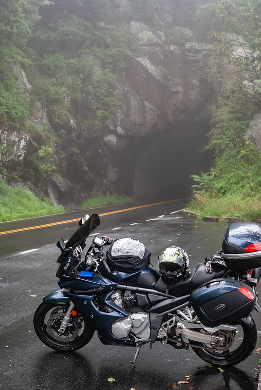 Tunnel through Marys Rock by Scott Baker, on Flickr
Lunch brought a short clearing of the weather for us but we immediately rode into pea-soup thick fog once we got close to the Parkway. It was so bad I ended up going out of my way for a bit and we could not get a picture of the sign saying we were there. However, we finally had some dry time late in the afternoon for a quick break
 Stator sitting on the Parkway by Scott Baker, on Flickr
And a stop at Otter Lake Falls that is fed by, you guessed it, Otter Lake which is itself fed by the upper half of Otter Creek (the falls also feeds the lower half of Otter Creek)
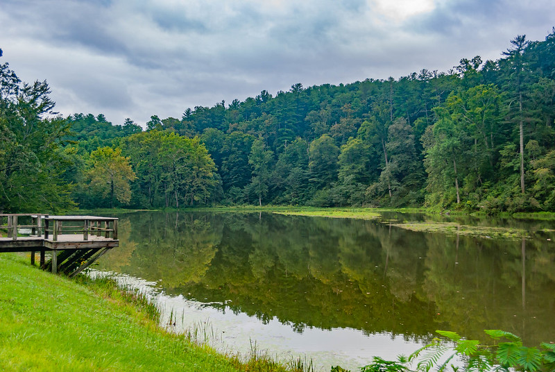 Otter Lake by Scott Baker, on Flickr
 Otter Lake Falls by Scott Baker, on Flickr
Last edited:
Such a cool trip!
In Boone NC and all I can say is WOW. Today totally made up for the last two days as I had to dig out my sunglasses from the bottom of the tank bag. The visit to Appomattox Courthouse was very powerful and, once the morning fog burned off, the ride was excellent. If anyone comes this way and is going southbound, be sure to check our Bent Mountain road in Roanoke - the set of curves going up the mountain made up for missing out on the closed section of the broken Parkway section
As I noted, the fog really made for an interesting start to the morning, but off to breakfast I went to another Mom and Pop place. Check out Granny Bees on Main Street next time you are in Appomattox
 Appomattox Main Street by Scott Baker, on Flickr
Off to the courthouse we went
 Appomattox Court House National Park by Scott Baker, on Flickr
Where the original courthouse for the town is now a visitor's center (albeit closed currently)
 Appomattox Court House by Scott Baker, on Flickr
And the Clover Hill Tavern where they printed out the Parole passes given to the Confederate soldiers. These passes allowed for folks to get supplies as needed and would allow soldiers to take their horses home (Confederate soldiers brought their own horses to use in battle which was unique from the way the North outfitted their troops)
 Clover Hill Tavern by Scott Baker, on Flickr
 Parole Pass Printers by Scott Baker, on Flickr
We finally made our way to the MacLean house where the surrender actually took place. The tour guide, a former Navy Sailor who served in Vietnam, explained how the process occurred and when Stator noted the difference in table styles, he explained that General Lee graduated from West Point 15 years before General Grant. This seniority, even recognized by General Grant, and the fact he arrived first gave General Lee the right to use the marble top table. Sadly the tables are only replicas, the actual ones are in the Smithsonian and a museum in Chicago. In fact, only the two vases on the fireplace and the couch behind the door where the tour guide is standing are original. Everything else is a replica now
 Parlor where Surrender Documents Signed by Scott Baker, on Flickr
As we started back to the parkway the fog finally cleared out and we enjoyed great skies for the next couple of days
 The Great Valley Overlook by Scott Baker, on Flickr
We stopped at Mabry Mill for a bit
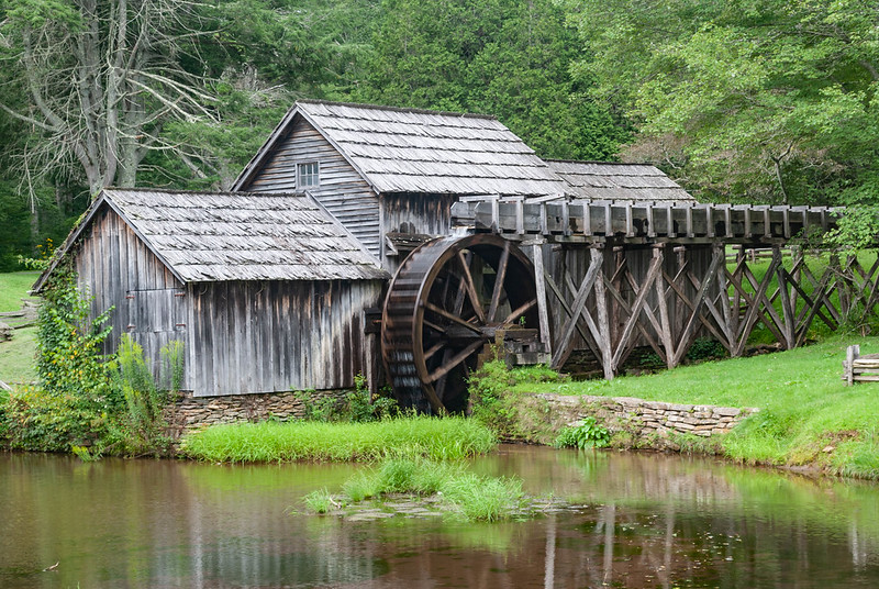 Mabry Mill by Scott Baker, on Flickr
then finally made it to North Carolina
 Crossing into North Carolina by Scott Baker, on Flickr
Getting into Boone late in the evening
 Sunset on Blue Ridge Parkway Boone NC by Scott Baker, on Flickr
As I noted, the fog really made for an interesting start to the morning, but off to breakfast I went to another Mom and Pop place. Check out Granny Bees on Main Street next time you are in Appomattox
Appomattox Main Street by Scott Baker, on FlickrOff to the courthouse we went
Appomattox Court House National Park by Scott Baker, on FlickrWhere the original courthouse for the town is now a visitor's center (albeit closed currently)
Appomattox Court House by Scott Baker, on FlickrAnd the Clover Hill Tavern where they printed out the Parole passes given to the Confederate soldiers. These passes allowed for folks to get supplies as needed and would allow soldiers to take their horses home (Confederate soldiers brought their own horses to use in battle which was unique from the way the North outfitted their troops)
Clover Hill Tavern by Scott Baker, on FlickrParole Pass Printers by Scott Baker, on FlickrWe finally made our way to the MacLean house where the surrender actually took place. The tour guide, a former Navy Sailor who served in Vietnam, explained how the process occurred and when Stator noted the difference in table styles, he explained that General Lee graduated from West Point 15 years before General Grant. This seniority, even recognized by General Grant, and the fact he arrived first gave General Lee the right to use the marble top table. Sadly the tables are only replicas, the actual ones are in the Smithsonian and a museum in Chicago. In fact, only the two vases on the fireplace and the couch behind the door where the tour guide is standing are original. Everything else is a replica now
Parlor where Surrender Documents Signed by Scott Baker, on FlickrAs we started back to the parkway the fog finally cleared out and we enjoyed great skies for the next couple of days
The Great Valley Overlook by Scott Baker, on FlickrWe stopped at Mabry Mill for a bit
Mabry Mill by Scott Baker, on Flickrthen finally made it to North Carolina
Crossing into North Carolina by Scott Baker, on FlickrGetting into Boone late in the evening
Sunset on Blue Ridge Parkway Boone NC by Scott Baker, on Flickr
Last edited:
Steve
GS Whisperer
If you want some exciting curves, just get off the Parkway at virtually any one of the exits and go both directions, then get back on the Parkway. The roads that cross the Parkway go through the gaps in the ridge, but they tend to follow just about every nook and cranny on the way up to the Parkway, then down the other side.
.
.
Scott, just got home from the Dragon and Cherahola Skyway. Came back to Asheville on the BRP.
Don’t know if I passed you or not. Quite a bit of fog on the top of the Skyway.
Don’t know if I passed you or not. Quite a bit of fog on the top of the Skyway.
Doubtful unless you rolled through Robbinsville around 730pm when I came in. In fact, today was a bittersweet day as I finished the ride down the Parkway getting into Cherokee about 630. Why couldn’t they have put a sign, even a small one, that said something to the effect it was ending? :sorrow:
The morning started off much like the day before but without the fog. A quick stop at Sims Pond for water and a view
 Sims Pond by Scott Baker, on Flickr
found this spillway into Sims Creek
 Sims Creek Spillway by Scott Baker, on Flickr
 Sims Creek by Scott Baker, on Flickr
Then ran across Boulder Field on the way to Linville Falls (that's a hike)
 Boulder Field Overlook by Scott Baker, on Flickr
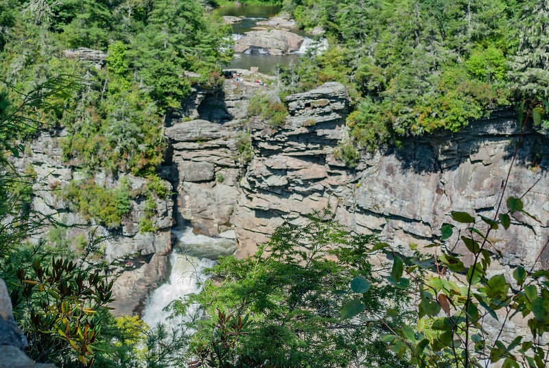 Linnville Falls by Scott Baker, on Flickr
Mount Mitchell in the background
 Mount Mitchell Overlook by Scott Baker, on Flickr
Once we arrived there, Stator and I hiked to the top of the mountain - we both agree going back down is so much easier.
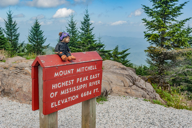 On Top of Mount Mitchell by Scott Baker, on Flickr
He asked why would anyone want to be buried on top of a mountain but understood when I explained it was because he died there while trying to prove it was the tallest back in the 1800s
 Elisha Mitchell Grave by Scott Baker, on Flickr
Our last water stop at Devil's Courthouse though I'm not sure how that rock got its name.
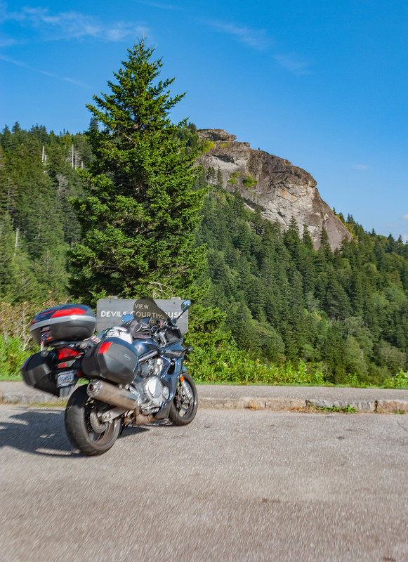 Devils Courthouse by Scott Baker, on Flickr
But the bike and I are in one piece, though the same can’t be said for my camera - as we started down the mountain, I picked the camera off of the bench where I laid it to take a video for the family. Unfortunately, I didn't notice the neck strap caught on the bottom of the bench and ripped the camera out of my hand breaking the mount for the lens. Fortunately, the camera is still good and the lens works if I hold it in place. I can also get the part to fix it which I'll try soon
I’ll head up Cherohola Skyway tomorrow stopping into Knoxville for a little bit then off to Cumberland Falls and points north. Should be home by Saturday afternoon unless I take the really long way home.
The morning started off much like the day before but without the fog. A quick stop at Sims Pond for water and a view
Sims Pond by Scott Baker, on Flickrfound this spillway into Sims Creek
Sims Creek Spillway by Scott Baker, on FlickrSims Creek by Scott Baker, on FlickrThen ran across Boulder Field on the way to Linville Falls (that's a hike)
Boulder Field Overlook by Scott Baker, on FlickrLinnville Falls by Scott Baker, on FlickrMount Mitchell in the background
Mount Mitchell Overlook by Scott Baker, on FlickrOnce we arrived there, Stator and I hiked to the top of the mountain - we both agree going back down is so much easier.
On Top of Mount Mitchell by Scott Baker, on FlickrHe asked why would anyone want to be buried on top of a mountain but understood when I explained it was because he died there while trying to prove it was the tallest back in the 1800s
Elisha Mitchell Grave by Scott Baker, on FlickrOur last water stop at Devil's Courthouse though I'm not sure how that rock got its name.
Devils Courthouse by Scott Baker, on FlickrBut the bike and I are in one piece, though the same can’t be said for my camera - as we started down the mountain, I picked the camera off of the bench where I laid it to take a video for the family. Unfortunately, I didn't notice the neck strap caught on the bottom of the bench and ripped the camera out of my hand breaking the mount for the lens. Fortunately, the camera is still good and the lens works if I hold it in place. I can also get the part to fix it which I'll try soon
I’ll head up Cherohola Skyway tomorrow stopping into Knoxville for a little bit then off to Cumberland Falls and points north. Should be home by Saturday afternoon unless I take the really long way home.
Last edited:
Steve
GS Whisperer
Should be home by Saturday afternoon unless I take the really long way home.
Don't forget to turn left when you see Roger. :-\\\
.
Thank you Bob for allowing Stator and I to drop in; we both enjoyed the visit. I’ll wait to post the picture I took of you two when I get home as the phone’s editing features aren’t doing that well.
The day started a little wet but Cherohola Skyway was a lot of fun and I didn’t want to leave the visitor’s center and museum at the end. I am already thinking about when and how I can make it back down to ride and visit the area more
The rains visited us again forcing me to wait a little bit before we could leave but it dried up and off to the skyway we went and took a moment to enjoy the view once the clouds cleared out some
 Overhill Cherokee Lookout Cherohola Skyway by Scott Baker, on Flickr
I bought one of the pictures that 129photos.com took of me as I rode by
 Scott Cherohala Skyway by Scott Baker, on Flickr
and we later stopped at Bob's where Stator met Beau
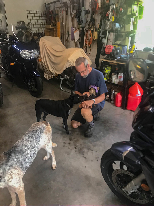 Bob introducing Stator to Beau by Scott Baker, on Flickr
My original plan was to make our way up to Somerset KY for the night but that didn't quite work out and, for the better in some respects, and so we stopped into Williamsburg KY instead. This would then give me more time to spend at Cumberland Falls the next day.
The day started a little wet but Cherohola Skyway was a lot of fun and I didn’t want to leave the visitor’s center and museum at the end. I am already thinking about when and how I can make it back down to ride and visit the area more
The rains visited us again forcing me to wait a little bit before we could leave but it dried up and off to the skyway we went and took a moment to enjoy the view once the clouds cleared out some
Overhill Cherokee Lookout Cherohola Skyway by Scott Baker, on FlickrI bought one of the pictures that 129photos.com took of me as I rode by
Scott Cherohala Skyway by Scott Baker, on Flickrand we later stopped at Bob's where Stator met Beau
Bob introducing Stator to Beau by Scott Baker, on FlickrMy original plan was to make our way up to Somerset KY for the night but that didn't quite work out and, for the better in some respects, and so we stopped into Williamsburg KY instead. This would then give me more time to spend at Cumberland Falls the next day.
Last edited: