Has anyone done any scouting in southern Indiana? With all the rain, I wonder if there is any flooded roads?
I was down there last weekend, and nothing was anywhere near flood stage. We have had a fair bit of rain, but I don't see any flooding on the current INDOT map.
There are a few road closings for construction that might affect us:
IN-62 west of Leavenworth and east of Sulphur is closed for a bridge project.
https://511in.org/map/event/incars-172302/@-86.48178,38.20687,12?show=incidents,construction,s tationsAlert,weatherWarningsAreaEvents,flooding
There aren't really any good secret workaround unless you enjoy gravel, so follow the detour signs (basically, you pop onto interstate 64 to the next exit) if you go thataway:
IN-58 just south of Ogilville (between Columbus and Freetown) is closed for a bridge replacement:
https://511in.org/map/event/incars-172878/@-86.02389,39.11415,14?show=incidents,construction,s tationsAlert,weatherWarningsAreaEvents,flooding
The "official" detour is ridiculous, so just find your way around on county roads. The obvious detours are paved, so it should be easy. We normally don't use this route anyway.
Highway 337 south of Corydon is closed:
https://511in.org/map/event/incars-172833/@-86.10877,38.12008,14?show=incidents,construction,s tationsAlert,weatherWarningsAreaEvents,flooding
The "official" detour is best; there are a LOT of roads that dead-end or turn to gravel in this area. We normally don't use this route anyway.
Here's the route copy/paste from last year, and the year before, with links where one can download GPX tracks.
In all, these are just too damn long, so I'd plan to cut a loop or two and some miles out of all these, if I were you.
Lots of disclaimers, so keep your wits about you.
-=-=-=-
The following GPX tracks follow roads that are flawed, freaky, filthy, and have all sorts of weird stuff going on. And sometimes the tracks ended up in places they shouldn't have, like unpaved roads. So stay alert, stay flexible, and stay upright.
But anyway, here they are if this sort of thing is the sort of thing that's your sort of thing:
Here's my Saturday track, pretty much the most intense twistacular kookoo kokonuts route I could dream up. This one's wild. Don't try to do the whole thing, seriously. LOTS of VERY narrow back roads.
Twisted Overload
https://www.bwringer.com/gpx/bedford...t-overload.gpx
It takes a lovely scenic and twisty back road route to and from Salem, and routes around the road closing in Salem (not needed now). Then another back road route to Borden, and a romp up and down and around the hills around Borden, shoots over to the spectacular Skyline Drive on a high ridge overlooking New Albany and Louisville (please stop if you want to look at the scenery... it's impossible to both ride and look). Then it goes up and down the Ohio river valley several times (Blunk Road is one of my favorites -- positively demented). There's a busy little country store in Elizabeth, a rather "authentic" biker bar in Mauckport (no guns), and a gorgeous but very narrow and twisty back road route from there to Corydon, then back through Salem via Beck's Mill Road.
This is the raw track, no cleanup or anything, wrong turns and all, so buyer beware. There is one very short, less than 1/4 mile, segment of gravel near the end of the day just outside Bono. Just work around it on the next road to the south.
Below are some more links to some of my area GPX tracks from past years. These are also pretty flawed, but could help show you a good time if you don't take them very seriously.
As ever, these routes are only a faint echo of the reality on the ground, and are the product of a deeply imperfect memory coupled with a terribly flawed computer translation of what may or may not be actual roads that may or may not be passable on two wheels shod with street tires.
Plus, in several spots I couldn't figure out how to alter an incorrect route I already created using Alltrails, so I just drew some alternates.
I cannot offer any assurances that these routes exist, or are paved, or are safe. There could be anything from dead animals to tractors, Orcs, dragons, weird cults, wormholes or even (horrors!) minivans out there. Yes, there WILL be gravel in every corner. There WILL be unexpected construction projects.
Take these routes as only the vaguest hand wave of a suggestion. Pay attention, stay sharp, CARRY A PAPER MAP (I will bring some), and you may eventually figure out how to get back to Bedford.
Still, this is Indiana, so there are no mountains to get trapped behind. Or bears. I did see a camel once.
Except for the "short" route, these make for a VERY long, exhausting day of intense twisties; there are lots of opportunities for shortcutting loops as needed, so please take advantage of these. Shoot for 200-250 miles.
Bedford 1 - 280 miles
https://www.alltrails.com/explore/ma...rd-1-280mi?u=i
https://www.bwringer.com/gs/bcgsrall...-280-miles.gpx
Starting at the Rosemount Motel in Bedford. Nice paved twisty road track. 280 miles. Includes detour around 2021 construction on 145 south of Birdseye. This is no longer needed, so stay on 145; it's much more fun. This one mostly goes
south of Bedford.
Bedford 2 - 305 miles
https://www.alltrails.com/explore/ma...-305-miles?u=i
https://www.bwringer.com/gs/bcgsrall...-305-miles.gpx
Nice scenic twisty road track starting at the Rosemount Motel in Bedford, Indiana. Paved. 305 miles is a lot, so choose where to cut off a loop by continuing on a main road as needed. Wesley Chapel Gulf, Orangeville Rise, Story, Tulip Trestle, etc. Includes small detour around construction on 135 for 2021 that isn't needed. This one mostly goes
north of Bedford.
BC North Short - 115 miles
https://www.alltrails.com/explore/ma...orth-short?u=i
https://www.bwringer.com/gs/bcgsrall...orth-Short.gpx
About 115 miles, originating from Bedford, IN. Nice shorter route, mostly
north of Bedford.
BC Rally Southern Classic - 289 miles
https://www.alltrails.com/explore/ma...th-classic?u=i
https://www.bwringer.com/gs/bcgsrall...rn-Classic.gpx
Starting from Bedford, IN, the classic southern route. Incredibly scenic and twisty. Closely related to Bedford 1.
-=-=-=-=-=-
And here are images you can print if you're so inclined and happen to have access to a larger format color laser:
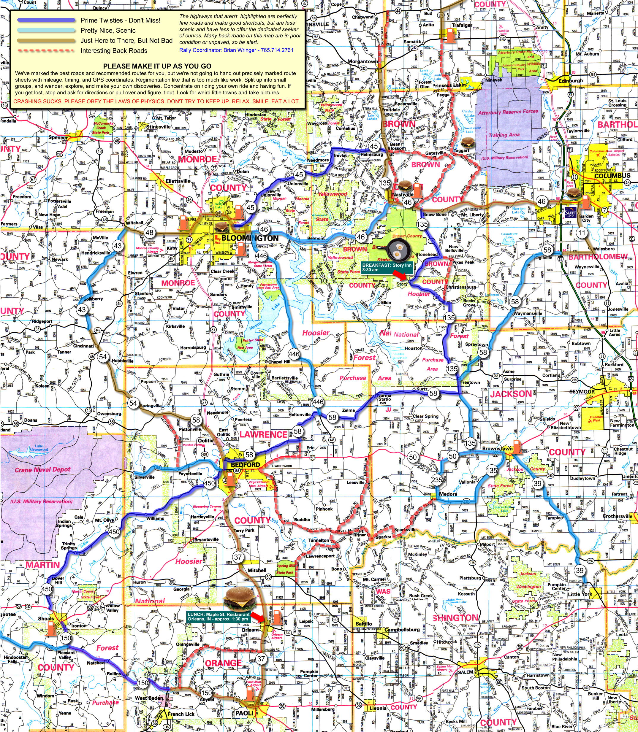
One more thing... if you like paper maps and have access to a color laser printer, this is an old one that still mostly works that you could print, or print in sections. This covers the "northern" stuff. Ignore the stuff about breakfast, lunch, etc... many of these places are long gone:
This is a large image file, 3MB:
 https://www.bwringer.com/gs/images/bc2008_map_hq.jpg
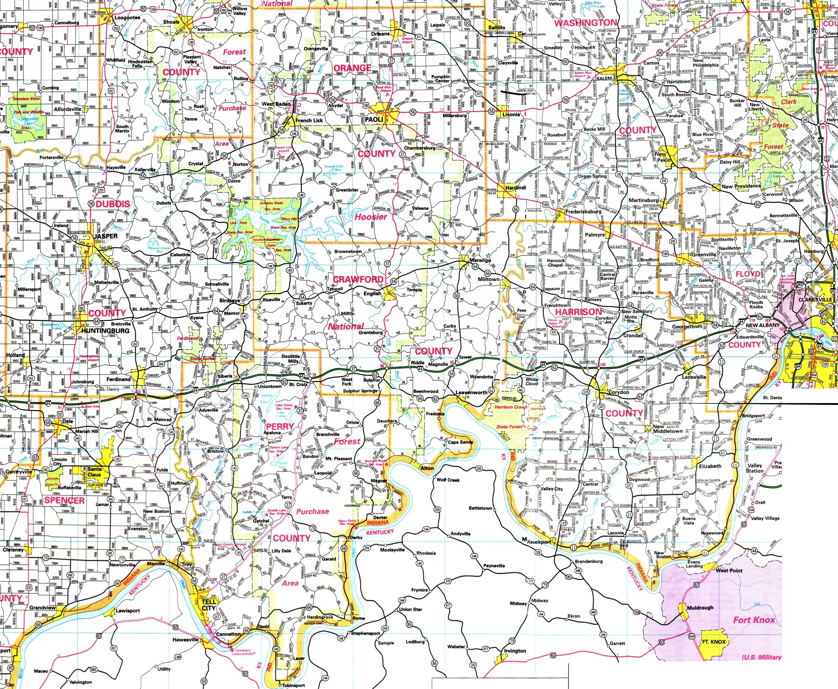
This is the southern part of the state. No routes marked, just a map. Again, this is a pretty large image, 3.4MB:
https://www.bwringer.com/gs/images/southern_in.jpg
I will print out and bring some copies of these if you aren't able to print them. As with any paper map, these sort of fudge a lot of details. And they are pretty old, so some things are a little different now (for example, IN-37/237 around Tell City has been reconfigured.)
")